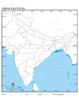
Where is India?
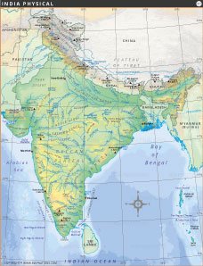
This India location map shows India's location in South Asia on a world map. India is bordered by Pakistan, China, Nepal, Bhutan, Bangladesh, and Myanmar, and has the Indian Ocean to the south. The map shows major latitude lines such as the Tropic of Cancer, which emphasizes India's strategic geographic importance on a global scale.

The culture of India is a vibrant blend of traditions, languages, festivals and arts. It boasts diversity in food, clothing, music, dance and religions. Family values, respect for elders, yoga, Ayurveda and spirituality shape daily life. Festivals like Diwali, Holi and Eid unite people, reflecting India's rich heritage and history.
Quick Facts About India
| Fact | Details |
|---|---|
| Official Name | Republic of India |
| Capital | New Delhi |
| Largest City | Mumbai |
| Official Language | Hindi, English |
| Area | 3,287,263 km² (1,269,219 sq mi) |
| Population | ~1.4 billion (2024 estimate) |
| Currency | Indian Rupee (INR) |
| Time Zone | IST (UTC+5:30) |
| Calling Code | +91 |
| Major Religions | Hinduism, Islam, Christianity, Sikhism, Buddhism, Jainism |
| Government | Federal Parliamentary Republic |
| President | Droupadi Murmu (as of 2024) |
| Prime Minister | Narendra Modi (as of 2024) |
| National Symbol | Lion Capital of Ashoka |
| Independence | August 15, 1947 (from Britain) |
| Bordering Countries | Pakistan, China, Nepal, Bhutan, Bangladesh, Myanmar |
| Highest Peak | Kanchenjunga (8,586 m) |
| Longest River | Ganges |
| National Animal | Bengal Tiger |
| National Bird | Indian Peacock |
| Drives on | Left side |


INDIA MAPS


WORLD COUNTRIES
- Afghanistan
- Albania
- Algeria
- Andorra
- Angola
- Antigua and Barbuda
- Argentina
- Armenia
- Australia
- Austria
- Azerbaijan
- Bahamas, The
- Bahrain
- Bangladesh
- Barbados
- Belarus
- Belgium
- Belize
- Benin
- Bhutan
- Bolivia
- Bosnia and Herzegovina
- Botswana
- Brazil
- Brunei
- Bulgaria
- Burkina Faso
- Burma (Myanmar)
- Burundi
- Cabo Verde
- Cambodia
- Cameroon
- Canada
- Central African Republic
- Chad
- Chile
- China
- Colombia
- Comoros Islands
- Congo, Dem. Rep. of the
- Congo, Republic of the
- Costa Rica
- Cote d'Ivoire
- Croatia
- Cuba
- Cyprus
- Czech Republic
- Denmark
- Djibouti
- Dominica
- Dominican Republic
- Ecuador
- Egypt
- El Salvador
- Equatorial Guinea
- Eritrea
- Estonia
- eSwatini (formerly Swaziland)
- Ethiopia
- Fiji
- Finland
- France
- Gabon
- Gambia, The
- Georgia
- Germany
- Ghana
- Greece
- Grenada
- Guatemala
- Guinea
- Guinea-Bissau
- Guyana
- Haiti
- Holy See
- Honduras
- Hungary
- Iceland
- India
- Indonesia
- Iran
- Iraq
- Ireland
- Israel
- Italy
- Jamaica
- Japan
- Jordan
- Kazakhstan
- Kenya
- Kiribati
- Korea, North
- Korea, South
- Kosovo
- Kuwait
- Kyrgyzstan
- Laos
- Latvia
- Lebanon
- Lesotho
- Liberia
- Libya
- Liechtenstein
- Lithuania
- Luxembourg
- Madagascar
- Malawi
- Malaysia
- Maldives
- Mali
- Malta
- Marshall Islands
- Mauritania
- Mauritius
- Mexico
- Micronesia, Federated States of
- Moldova
- Monaco
- Mongolia
- Montenegro
- Morocco
- Mozambique
- Namibia
- Nauru
- Nepal
- Netherlands
- New Zealand
- Nicaragua
- Niger
- Nigeria
- North Macedonia, Republic of
- Norway
- Oman
- Pakistan
- Palau
- Panama
- Papua New Guinea
- Paraguay
- Peru
- Philippines
- Poland
- Portugal
- Qatar
- Romania
- Russia
- Rwanda
- Saint Kitts and Nevis
- Saint Lucia
- Saint Vincent & the Grenadines
- Samoa
- San Marino
- Sao Tome and Principe
- Saudi Arabia
- Senegal
- Serbia
- Seychelles
- Sierra Leone
- Singapore
- Slovakia
- Slovenia
- Solomon Islands
- Somalia
- South Africa
- South Sudan
- Spain
- Sri Lanka
- Sudan
- Suriname
- Sweden
- Switzerland
- Syria
- Tajikistan
- Tanzania
- Thailand
- Timor-Leste
- Togo
- Tonga
- Trinidad and Tobago
- Tunisia
- Turkey
- Turkmenistan
- Tuvalu
- Uganda
- Ukraine
- United Arab Emirates
- United Kingdom
- United States of America
- Uruguay
- Uzbekistan
- Vanuatu
- Venezuela
- Vietnam
- Yemen
- Zambia
- Zimbabwe
