Where is Israel?
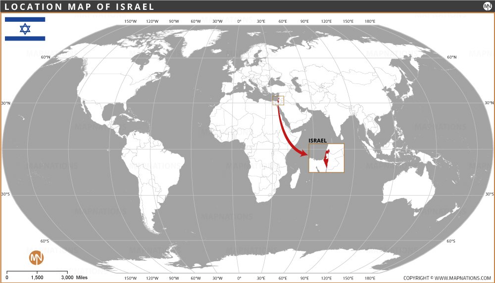
This world location map, highlighting Israel in red, shows its position in the Middle East on a global scale. Israel is located at approximately 31°N latitude and 35°E longitude, bordered by Lebanon to the north, Syria to the northeast, Jordan to the east, and Egypt to the southwest, while the Mediterranean Sea lies to the west.

The map includes important geographic landmarks such as the Prime Meridian (0° longitude), the Equator (0° latitude), the Tropic of Cancer (23.5°N), and the Arctic Circle (66.5°N), providing a clear global perspective. Despite its small size, 22,145 sq km (8,630 sq mi), Israel holds historical, cultural, and geopolitical significance.
Quick Facts About the Israel
| Fact | Details |
|---|---|
| Official Name | State of Israel (Medinat Yisrael) |
| Capital | Jerisraellem (disputed, some countries recognize Tel Aviv) |
| Largest City | Jerisraellem |
| Continent | Asia (Middle East) |
| Geographic Coordinates | 31°N latitude, 35°E longitude |
| Area | 22,145 km² (8,630 mi²) |
| Population | ~9.7 million (as of 2024) |
| Official Language | Hebrew (Arabic has special status) |
| Currency | Israeli New Shekel (ILS) |
| Time Zones | UTC +2 (Standard), UTC +3 (Daylight Saving) |
| Calling Code | +972 |
| Internet TLD | .il |
| Independence | May 14, 1948 (from British Mandate of Palestine) |
| National Symbol | Menorah |
| National Motto | None officially, but often "Am Yisrael Chai" |
| Drives On | Right |
WORLD COUNTRIES
- Afghanistan
- Albania
- Algeria
- Andorra
- Angola
- Antigua and Barbuda
- Argentina
- Armenia
- Australia
- Austria
- Azerbaijan
- Bahamas, The
- Bahrain
- Bangladesh
- Barbados
- Belarus
- Belgium
- Belize
- Benin
- Bhutan
- Bolivia
- Bosnia and Herzegovina
- Botswana
- Brazil
- Brunei
- Bulgaria
- Burkina Faso
- Burma (Myanmar)
- Burundi
- Cabo Verde
- Cambodia
- Cameroon
- Canada
- Central African Republic
- Chad
- Chile
- China
- Colombia
- Comoros Islands
- Congo, Dem. Rep. of the
- Congo, Republic of the
- Costa Rica
- Cote d'Ivoire
- Croatia
- Cuba
- Cyprus
- Czech Republic
- Denmark
- Djibouti
- Dominica
- Dominican Republic
- Ecuador
- Egypt
- El Salvador
- England
- Equatorial Guinea
- Eritrea
- Estonia
- eSwatini (formerly Swaziland)
- Ethiopia
- Fiji
- Finland
- France
- Gabon
- Gambia, The
- Georgia
- Germany
- Ghana
- Greece
- Grenada
- Guatemala
- Guinea
- Guinea-Bissau
- Guyana
- Haiti
- Holy See
- Honduras
- Hungary
- Iceland
- India
- Indonesia
- Iran
- Iraq
- Ireland
- Israel
- Italy
- Jamaica
- Japan
- Jordan
- Kazakhstan
- Kenya
- Kiribati
- Korea, North
- Korea, South
- Kosovo
- Kuwait
- Kyrgyzstan
- Laos
- Latvia
- Lebanon
- Lesotho
- Liberia
- Libya
- Liechtenstein
- Lithuania
- Luxembourg
- Madagascar
- Malawi
- Malaysia
- Maldives
- Mali
- Malta
- Marshall Islands
- Mauritania
- Mauritius
- Mexico
- Micronesia, Federated States of
- Moldova
- Monaco
- Mongolia
- Montenegro
- Morocco
- Mozambique
- Namibia
- Nauru
- Nepal
- Netherlands
- New Zealand
- Nicaragua
- Niger
- Nigeria
- North Macedonia, Republic of
- Norway
- Oman
- Pakistan
- Palau
- Panama
- Papua New Guinea
- Paraguay
- Peru
- Philippines
- Poland
- Portugal
- Qatar
- Romania
- Russia
- Rwanda
- Saint Kitts and Nevis
- Saint Lucia
- Saint Vincent & the Grenadines
- Samoa
- San Marino
- Sao Tome and Principe
- Saudi Arabia
- Senegal
- Serbia
- Seychelles
- Sierra Leone
- Singapore
- Slovakia
- Slovenia
- Solomon Islands
- Somalia
- South Africa
- South Sudan
- Spain
- Sri Lanka
- Sudan
- Suriname
- Sweden
- Switzerland
- Syria
- Tajikistan
- Tanzania
- Thailand
- Timor-Leste
- Togo
- Tonga
- Trinidad and Tobago
- Tunisia
- Turkey
- Turkmenistan
- Tuvalu
- Uganda
- Ukraine
- United Arab Emirates
- United Kingdom
- United States of America
- Uruguay
- Uzbekistan
- Vanuatu
- Venezuela
- Vietnam
- Yemen
- Zambia
- Zimbabwe


