UNITED KINGDOM MAP
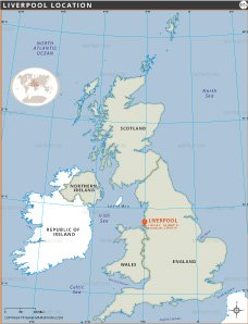
This detailed political map of the United Kingdom shows the geographic and administrative layout of England, Scotland, Wales and Northern Ireland. It highlights the country's borders, making it easy to identify each constituent nation. Major cities and capitals, including London, Edinburgh, Cardiff and Belfast, are prominently marked, providing information about major urban centers.
The map shows an extensive network of major roads and highways that connect cities throughout the region, along with important rivers such as the Thames, Severn and Clyde. These waterways and routes emphasize the importance of transportation and infrastructure within the UK.

Natural landmarks are also highlighted, with major mountain peaks such as Ben Nevis in Scotland and Snowdon in Wales identified by their height. National parks, including the Lake District, Snowdonia and the Cairngorms, are outlined, reflecting the country's diverse natural beauty.
Nearby islands, such as the Isle of Man, Isle of Wight, Shetland Islands and Isles of Scilly, are clearly represented, along with surrounding water bodies, including the North Atlantic Ocean, North Sea, Irish Sea and English Channel. These features provide context to the UK's maritime importance and its relationship with neighbouring countries.
Airports, ports and ferry routes are also labelled, reflecting the transport networks that link the UK internally and with the rest of the world. Additionally, national boundaries and division regions provide a comprehensive understanding of the political geography of the United Kingdom.
This map is a valuable resource for students, travellers and professionals seeking to learn or understand the geography of the UK. It provides a comprehensive overview of the region's urban centres, natural landscapes and transport networks, all presented with clear labelling and geographic coordinates for navigation and reference.
- Afghanistan
- Albania
- Algeria
- Andorra
- Angola
- Antigua and Barbuda
- Argentina
- Armenia
- Australia
- Austria
- Azerbaijan
- Bahrain
- Bangladesh
- Barbados
- Belarus
- Belgium
- Belize
- Benin
- Bhutan
- Bolivia
- Bosnia and Herzegovina
- Botswana
- Brazil
- Brunei
- Bulgaria
- Burkina Faso
- Burma (Myanmar)
- Burundi
- Cabo Verde
- Cambodia
- Cameroon
- Canada
- Central African Republic
- Chad
- Chile
- China
- Colombia
- Comoros Islands
- Democratic Republic of the Congo
- Costa Rica
- Cote d'Ivoire
- Croatia
- Cuba
- Cyprus
- Czechia
- Denmark
- Djibouti
- Dominica
- Dominican Republic
- Ecuador
- Egypt
- El Salvador
- England
- Equatorial Guinea
- Eritrea
- Estonia
- eSwatini (formerly Swaziland)
- Ethiopia
- Federated States of Micronesia
- Fiji
- Finland
- France
- Gabon
- Gambia, The
- Georgia
- Germany
- Ghana
- Greece
- Grenada
- Guatemala
- Guinea
- Guinea-Bissau
- Guyana
- Haiti
- Holy See
- Honduras
- Hungary
- Iceland
- India
- Indonesia
- Iran
- Iraq
- Ireland
- Israel
- Italy
- Jamaica
- Japan
- Jordan
- Kazakhstan
- Kenya
- Kiribati
- North Korea
- South Korea
- Kosovo
- Kuwait
- Kyrgyzstan
- Laos
- Latvia
- Lebanon
- Lesotho
- Liberia
- Libya
- Liechtenstein
- Lithuania
- Luxembourg
- Madagascar
- Malawi
- Malaysia
- Maldives
- Mali
- Malta
- Marshall Islands
- Mauritania
- Mauritius
- Mexico
- Moldova
- Monaco
- Mongolia
- Montenegro
- Morocco
- Mozambique
- Namibia
- Nauru
- Nepal
- Netherlands
- New Zealand
- Nicaragua
- Niger
- Nigeria
- Norway
- Oman
- Pakistan
- Palau
- Panama
- Papua New Guinea
- Paraguay
- Peru
- Philippines
- Poland
- Portugal
- Qatar
- Republic of North Macedonia
- Romania
- Russia
- Rwanda
- Saint Kitts and Nevis
- Saint Lucia
- Saint Vincent & the Grenadines
- Samoa
- San Marino
- Sao Tome and Principe
- Saudi Arabia
- Scotland
- Senegal
- Serbia
- Seychelles
- Sierra Leone
- Singapore
- Slovakia
- Slovenia
- Solomon Islands
- Somalia
- South Africa
- South Sudan
- Spain
- Sri Lanka
- Sudan
- Suriname
- Sweden
- Switzerland
- Syria
- Tajikistan
- Taiwan
- Tanzania
- Thailand
- The Bahamas
- Timor-Leste
- Togo
- Tonga
- Trinidad and Tobago
- Tunisia
- Turkey
- Turkmenistan
- Tuvalu
- Uganda
- Ukraine
- United Arab Emirates
- United Kingdom
- United States of America
- Uruguay
- Uzbekistan
- Vanuatu
- Venezuela
- Vietnam
- Yemen
- Zambia
- Zimbabwe


